Determining Bearing and Distance to Site
Follow these steps to determine bearing and distance to a survey site with GPS coordinates entered into the Facility Location field.
-
From the Site List window, tap
 Site Map to open the map view.
Map View - All Survey Sites
-
Tap on a site balloon (
 ) to open the site's location information pop-up window.
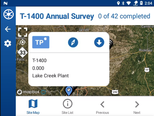
Site Location Information Pop-up Window
You may have to zoom in to see individual sites (tap in map and spread fingers to zoom in; pinch with fingers to zoom out).
-
Tap the
 icon in the location information pop-up window to open the Site Locator.
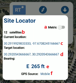
Site Locator
Use the Site Locator to:
-
Toggle the Metric option on and off.
-
See the number of GPS satellites being tracked.
-
See latitude and longitude coordinates for your current location.
-
See latitude and longitude coordinates for the target site's location.
-
View a real time indication of bearing and distance to the target site.
-
Identify the source of GPS data.
-
-
To close the Site Locator, tap the screen anywhere outside of it's window.
As of PCS Field Data Collector version 1.12, the Site Locator window is accessible directly from the Info, Inspection, and Maintenance pages by tapping the ![]() icon. See Access Site Locator Tool from Site Record Pages for details.
icon. See Access Site Locator Tool from Site Record Pages for details.