Database Settings
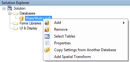
Right click on a specific database to display a number of available options.

Database Settings
-
Add—allows the addition of databases from Ms Access, Personal GeoDb databases, or via database connections
-
Remove—removes the database connection from the solution
-
Select Tables – select layers/tables from a specific database that are to be part of the project
-
Properties – allows the user to View/Edit information about the database in the Properties window
-
Copy Settings from Another Database – in case database names/locations have changed, users can move settings to the new database (see below for details)
-
Add Spatial Transform—Allows the projection of the project, databases, or individual tables to be defined within CartoPac, as opposed to how the data comes into CartoPac (through ArcMap, SQL Server, etc) so that the transformation to WGS84, the native projection used in the mobile environment, to be transformed accurately (see below for details)